The Basics of Satellite Imaging: A Comprehensive Guide for Beginners

The world of satellite imaging has transformed our ability to observe and monitor Earth’s surface from a birds-eye view. Thanks to progress, we now have access to visuals that offer unique insights into our planet. This guide aims to provide beginners with an introduction to the fundamentals of satellite imaging.
What Does Satellite Imaging Involve?
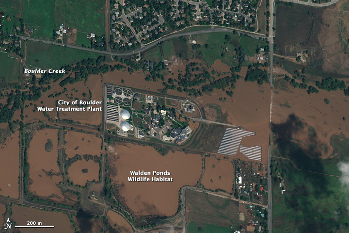
So, what is satellite imaging? Satellite imaging involves gathering data and capturing images of Earth’s surface using satellites orbiting the globe. These satellites are equipped with sensors and cameras that enable them to capture high-quality images from space. The imagery obtained through satellite imaging plays a role in studying aspects of Earth, including weather patterns, land usage, urban development, natural disasters, and changes in vegetation over time.
Varieties of Satellites
Various types of satellites serve imaging purposes. Remote sensing satellites are specifically designed to capture images and data about Earth. They can be categorized into two groups;
- Optical Satellites: Optical satellites utilize light and infrared radiation to capture images. These satellites can capture high-quality images that offer information about land coverage, vegetation health, and other surface characteristics.
- Synthetic Aperture Radar (SAR) Satellites: Synthetic Aperture Radar (SAR) Satellites utilize radio waves to generate images in cloud cover or nighttime instances when optical sensors may not be effective. SAR imagery aids in identifying alterations in landscapes caused by events like earthquakes or volcanic activities.
Image Resolution
Resolution plays a role in satellite imagery as it dictates the level of detail an image can present. There are two categories of resolution:
- Spatial Resolution: This pertains to the extent of detail captured on the ground by a satellite sensor. Higher spatial resolution enables the observation of details on Earth’s surface.
- Spectral Resolution: Spectral resolution concerns the number of bands or wavelengths a satellite sensor detects. This data is crucial for identifying the composition of objects such as vegetation, water bodies, and soil types.
Applications of Satellite Imagery
Satellite imaging finds applications across industries and sectors. Some key areas where satellite imagery exists include;
- Agriculture: Satellite images are helpful for farmers to monitor their crops, assess irrigation requirements, and spot signs of pests or diseases.
- Environmental Monitoring: Environmental monitoring involves using satellite imagery to study deforestation trends, evaluate the impact of climate change, and gain insights into Earth’s environment.
- Disaster Management: During disasters like hurricanes or wildfires, satellite images assist emergency responders in evaluating damage, planning evacuations, and coordinating relief efforts.
- Urban Planning: City planners use satellite images to analyze growth patterns, track infrastructure development, and monitor changes in land use over time.
- Defense and Security: Governments use satellite imagery for intelligence-gathering activities, border surveillance operations, and monitoring security threats.
Advancements in Satellite Imaging Technology
The continuous advancements in satellite imaging technology have significantly enhanced image quality and capabilities. The ongoing technological progress has unlocked opportunities for utilizing and analyzing satellite images.
Improved Resolution: One notable improvement is the enhanced resolution capability of satellites. These satellites are equipped with sensors that can precisely capture images, allowing us to observe the most minor features on Earth’s surface. This improved resolution provides information for various purposes, such as urban planning and land monitoring.
High-Speed Data Transmission: One notable advancement is the ability for satellites to swiftly transmit amounts of data to Earth, facilitating real-time monitoring and analysis. This feature proves crucial in situations like disaster response, where quick dissemination of information is vital.
Advances in Sensor Technology: The sensors utilized in satellite imaging have also seen improvements. Recent sensors can capture images across spectral ranges, offering valuable insights into various environmental factors like vegetation health and water quality. Additionally, the development of imaging allows for precise classification and analysis of different materials found on Earth’s surface.
As technology progresses rapidly, the future of satellite imaging will show promise. Anticipate enhancements in resolution sensors that can capture more detailed images from space. Furthermore, ongoing research aims to enhance the accuracy and speed of processing amounts of collected data.
Conclusion
Satellite imaging has truly revolutionized our understanding of Earth and its processes. From monitoring weather patterns to observing environmental changes, this technology provides us with invaluable insights that were once unimaginable. In this beginners’ guide, understanding the fundamentals can lead to admiration for the capabilities of these cameras and sensors that orbit around us.


